BARING HEAD LIGHTHOUSE LOOP | WAINUIOMATA | WELLINGTON
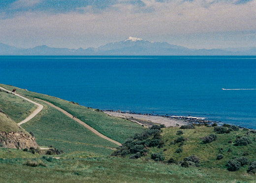
The Baring Head Lighthouse walk is a coastal loop track that climbs from the Wainuiomata river mouth up onto a small grassy plateau with sweeping ocean views back towards Wellington. The pathway then meanders down to the southern coast and then back along the river. The walk includes a lower section - which follows the river - then a higher ridge or plateau section - which has the ocean views back towards Wellington city. From this vantage point you can also see the South Island mountain Tapuae-o-Uenuku - which is part of the Kaikora mountain range.
At either end of this loop walk there is no avoiding a steep climb or descent - regardless of which direction you are going. But don’t worry, it’s relatively short and sharp.

When choosing the direction it might be good idea to consider the wind direction. If you’d prefer the wind at you back when walking the higher more exposed section, then go clockwise if it is a southerly, anti-clockwise it is a northerly. That said, we (Sonya and myself) completed the circuit on an unusually calm and sunny spring Sunday, so we have limited knowledge of a more elemental weather experience.
To get to the trailhead, we took the main route from Wellington; first on the motorway, then along the Petone waterfront (which always seems to have a traffic jam), past Wainuiomata and then down the road towards the coast, passing the Orongorongo park along the way. The carpark for the walk is on the right, just before you get to the beach.
On a previous time we did this walk, we first turned left and headed down the river, approaching the loop in a clockwise manner. So this time we decided to do the walk in the opposite direction. First we crossed the river on a bridge, then immediately turned right and climbed up steeply through some low scrub and gorse towards the ridge. About halfway up the drivable backroad, there is a fork. We took the option that said it lead to a viewpoint, which we arrived at after about 20 minutes of puffing up.

Finally we emerged onto a grassy plateau which looked down onto the ocean expanse and back towards Wellington. The curves of small rocky bays extended below and waves from a small clean swell shimmered in the sunlight. After a recovery lie down in the grass, we then followed the undulating ridge south towards the peninsula and lighthouse. The terrain was primarily rolling open fields punctuated with few solitary trees.
At several points on our walk side-paths descended to the coast. Below on the rocky beaches a few people were fishing and diving. A cycle and walking trail also continued around the coast towards Pencarrow and eventually Eastbourne. Wellington city could be seen beyond that.
Continuing along the ridge line, we eventually climbed to a turnoff located near a lone chimney from a presumably burned down old house. If you go up the hill you will find some abandoned and decaying historic WW2 bunkers - no doubt built to protect against some kind invading (or lost?) flotilla . We could see out over the lighthouse here, which was surrounded by a cluster of farm buildings. There also appeared to be a number of old vans and cars in various states of disrepair, and a few radio aerials read to receive some sort of signal. In the far distance and accross the water were the snowy peaks of the Southern Alps.

The modest and slightly squat Baring Head Lighthouse was one of the last major stations to be built in New Zealand - constructed in 1934 and fully switched on in 1935. The lighthouse that preceded it was around the corner at Pencarrow Head, but this was shut down when Baring Head was built.
The land the lighthouse built on was presented to the government by a local farmer, Eric Riddiford. Being close to Wellington, this was a popular posting for lighthouse keepers and their families. Children were able to attend school nearby which was an advantage that most other light stations did not provide. In 1989 the lighthouse was fully automated.

Carrying on along the loop, near the southern end of the peninsular, the trail descends quite steeply, with views over the Wainuiomata beach. At the bottom it then turns back northwards, following the river over some rocky and dry terrain.
Towards the end we passed the pump house, which we had visited before, and then we crossed the fields back to the bridge and carpark.
The walk was about 6.5km and took about three hours for us to complete, moving at a slow ambling speed.
Photos taken on a Nikon FM3a, Nikkor 35mm f1.4, Nikkor 105mm f1.8 and Cinestill 800T

Leave a comment